


Hurricane Imelda has strengthened as it bears down on Bermuda today, with the National Hurricane Center now reporting current sustained winds of 100 mph and some additional intensification as possible before the storm passes close to the island tonight.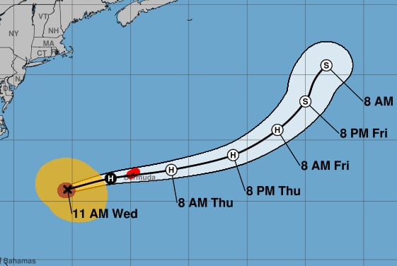 Hurricane Imelda is forecast to have wind gusts in the 120 mph to 125 mph region later today and perhaps when it makes its closest pass by Bermuda.
At this time, the majority of forecast models suggest the eve of hurricane Imelda will pass offshore of Bermuda, but meteorologists warn of the potential for destructive winds, high waves and possible storm surge that could affect the island.
Of course, Bermuda is no stranger to tropical storms and hurricanes given its location, while the island is home to a significant concentration of professionals in the catastrophe reinsurance, catastrophe bonds and insurance-linked securities (ILS) space, so as locations go it is among the best prepared for any storms.
Add to this robust building codes and preparedness plans, as well as year’s of experience in dealing with the impacts of major storms and Bermuda will certainly weather hurricane Imelda like it has many others in the past.
BMS Group Senior Meteorologist Andrew Siffert provides some useful insights into Imelda’s expected passage close to Bermuda, “Over the last 24 hours, the island of Bermuda has already experienced windy conditions with southerly winds gusting to 40 mph at one point yesterday as Humberto passed well west of the island. Based on our BMS iVision Verisk Respond wind swath below, Bermuda could see Imelda pass about 40 miles south of the island with 80 mph wind gusts, but as shown in the image, even stronger winds will be near the core of the storm, so track is critical to what type of strong winds Bermuda might experience. This means Bermuda could experience a Category 2 hurricane. Still, one thing is that winds will blow at an unusual strong direction as Imelda passes to the south of the island, where typically the strongest winds come from the south, where in this case the strongest winds could be blowing from the Northeast / North as Imelda passes just to the south of the Island. This could result in an unusual damage pattern not seen on the island. However, Bermuda has some of the highest building standards, so overall damage should be limited.”
But Siffert also highlights a potential feature of this storm that is being discussed among many other meteorologists, the potential for a sting jet as Imelda transitions towards becoming extratropical.
Siffert noted, “Nevertheless, given the unusual setup with Imelda interacting with the upper-level trough, some models suggest a strong jet-type interaction may occur. This is where mid-troposphere (jet stream winds) descend down to the surface. There were some characteristics of this on the back side of Milton when it made landfall south of Tampa last year. This could result in stronger winds occurring on the back side of Imelda as the storm passes.”

The National Hurricane Center said in its latest update on hurricane Imelda, “Air Force Hurricane Hunter aircraft data indicate that maximum sustained winds have increased to near 100 mph (155 km/h) with higher gusts. Some additional strengthening is possible before Imelda passes close to Bermuda tonight. Imelda is then expected to become an extratropical low on Thursday, with gradual weakening forecast thereafter. Hurricane-force winds extend outward up to 60 miles (95 km) from the center and tropical-storm-force winds extend outward up to 230 miles (370 km).”
Coastal storm surge flooding is possible in Bermuda in areas of onshore winds, the NHC explained, as well as up to 4 inches of rainfall as Imelda passes.
Bermuda’s building codes and general preparedness for hurricanes will help the island weather this storm, but power outages and disruption are possible should some of Imelda’s strongest winds hit, along with downed trees and some structural damage.
As is typical, businesses in the insurance, reinsurance and ILS industry began their contingency preparations well in advance of hurricane Imelda’s approach and many offices will close until the storm has passed. Bermuda has weathered much worse hurricanes before and is expected to cope well again.
We hope everyone in Bermuda stays safe as Imelda passes and we expect to see business as usual quickly resurfacing once the storm has moved away.
You can track this and every Atlantic hurricane season development using the tracking map and information on our dedicated page.
